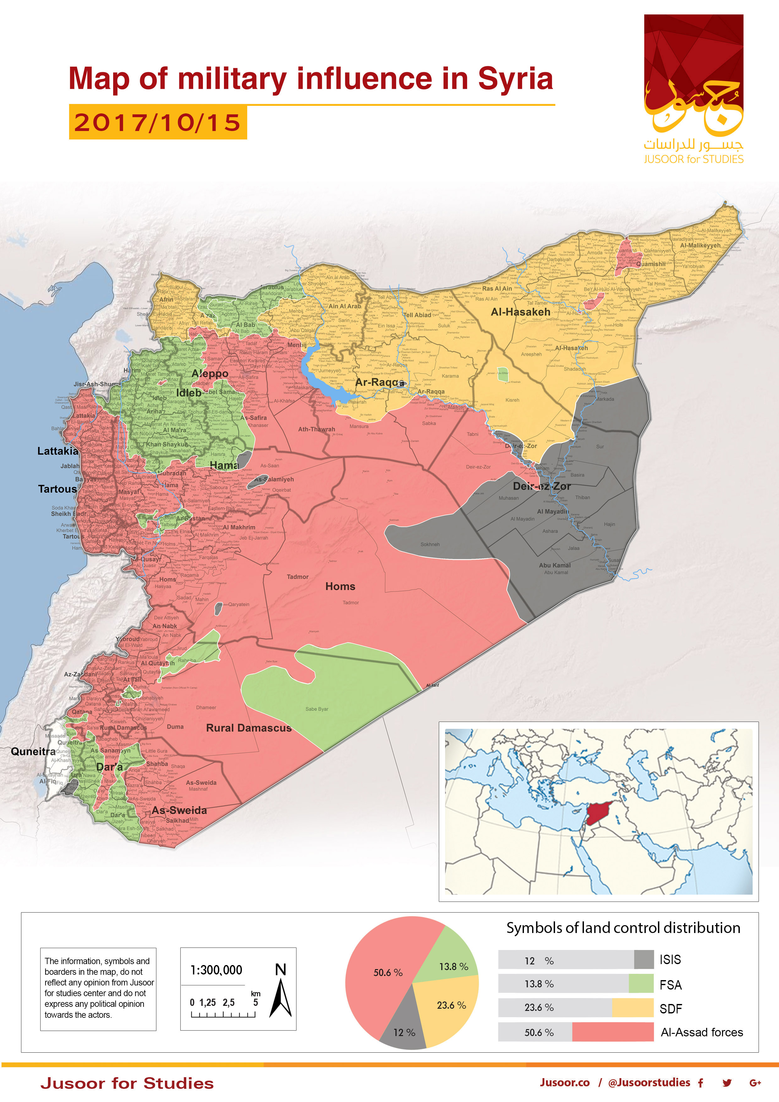
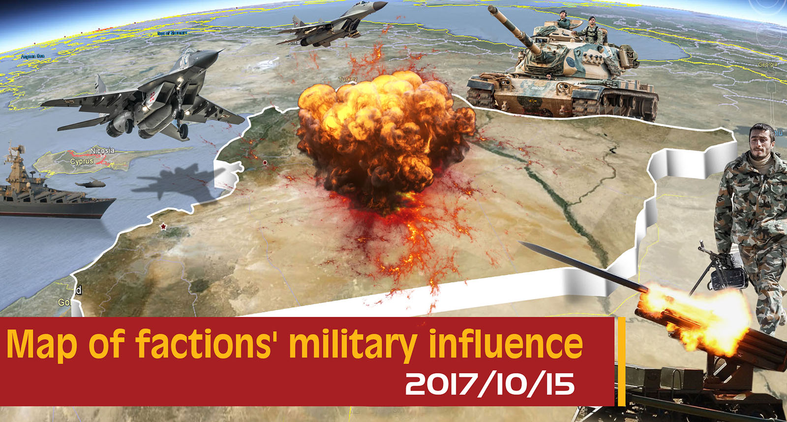
Map of military influence in Syria 15-10-2017
Jusoor for Studies Center issued the map of military influence in Syria for the first half of October 2017, as it shows a constant change in the total military influence percentage between the different forces. There is a notable increase in the total influence of Assad forces and Syria Democratic Forces (SDF) on the account of ISIS and the Free Syrian Army (FSA).
The map shows a constant shrinkage in ISIS-controlled areas comparing to the mid of September 2017 at the expense of Assad forces and SDF, whereby ISIS controls about 12% of the Syrian areas with 2.6% decrease of the total percentage.
On the other hand, pro-Assad forces control 50.6% of areas in Syria with 6.5% increase comparing to September 2017. As for the Syrian opposition, FSA controls 13.8 % with a decrease of 4.1% comparing to September 2017. Furthermore, SDF controls 90% of Raqqa city and the total percentage of its influence is 23.6% of the Syrian areas with an increase of 1.2%.
Between September 15, 2017, and October 15, 2017, many fronts have witnessed violations concerning the de-escalation zone agreement as follows: Ein Tarma, Jobar, and Hosh al-Dawahra without any changes in the military influence. The violation also took place in al-Manshiya District in Daraa without any changes in the points of engagement. Moreover, another violation took place in Homs Northern Countryside after an attack by FSA north Hirbnafsah town, as the factions had controlled many checkpoints but withdrew after a short period of time.
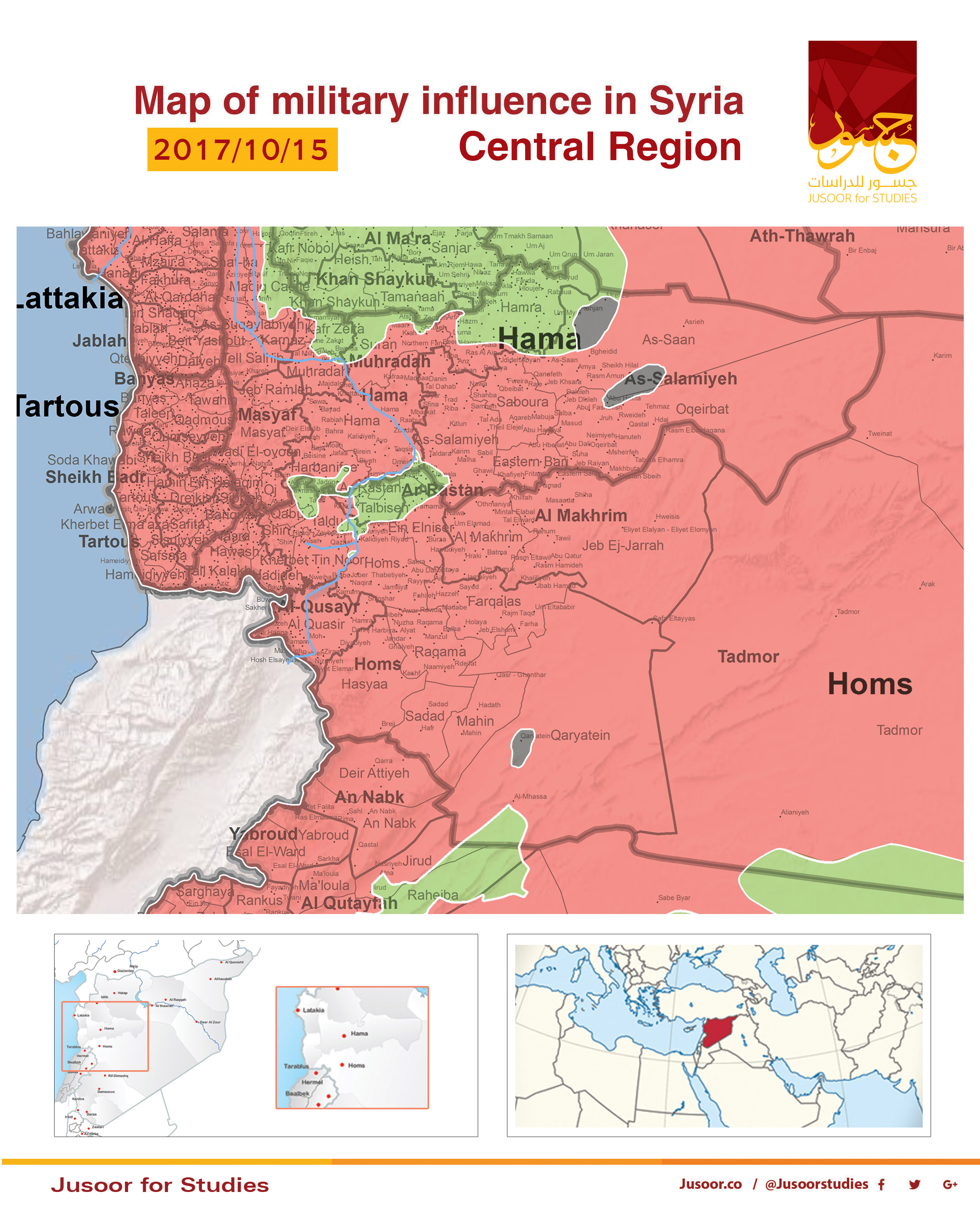
Central and Northern Region:
The map shows a slight change of the controlled areas in the Central and Northern Region by different sides between October 1, 2017, and October 15, 2017.
Many ceasefire violations have taken place in the north and extended to all surrounding areas due to the attack by HTS in Hama eastern rural on September 19, 2017, that witnessed a temporary advance of HTS in many villages on the account of Assad forces. However, the last party was able to recapture these villages and made progress through Al-Tulaysiyah and Shatheh axes with an attempts to seize Atshan and Taman’a towns. Furthermore, Assad forces were able to control Umm Hartein and Qubeibat villages. FSA has recently recaptured all the previously-mentioned areas while HTS attacked and controlled Abu Dali village in addition to many surrounding towns and hills on October 5, 2017. It worth mentioning that the total military influence has remained the same between all sides.
On October 9, 2017, ISIS combatants have sneaked from a besieged pocket by pro-Assad forces in Uqayribat into Rahjan village extreme north-east of Hama, which was controlled by FSA. ISIS controlled Rahjan village in addition to many surrounding towns and hills.
ISIS combatants have launched a surprise attack on Assad forces’ posts in Al-Qaryatayn town 70 KM south-east of Homs and controlled the town in addition to many hills southward and eastward.
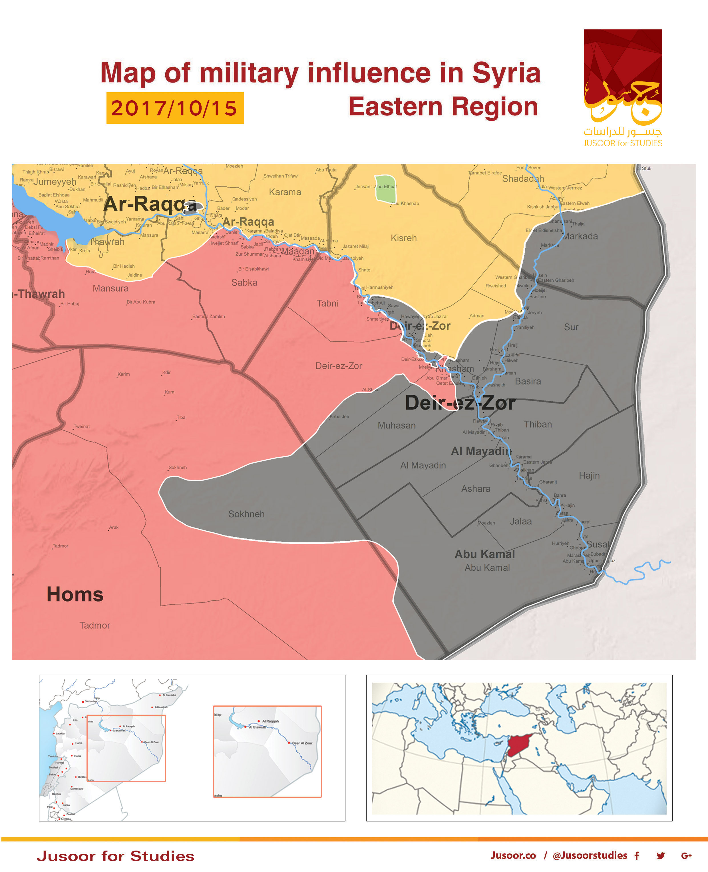
The Eastern Region:
The map shows different percentages of influence by different sides in the Eastern Region between October 1, 2017, and October 15, 2017.
ISIS combatants have waged an extensive attack from different axes in Al Badia, which ended by controlling al-Shola and Kabajib towns along the highway between Deir ez-Zor and Al Sukhna in addition to a ridge overlooking Al Sukhna city and al-Hamimah town south-east of Palmyra.
ISIS attack took place after losing extensive areas in the southern rural of Raqqa city and eastern rural of Deir ez-Zor Province in addition to the parameter of Deir ez-Zor military airbase. Assad forces were able to control Khasham and Mazlum strategic towns, which has led to besieging ISIS in few villages north of Uqayribat.
Concerning SDF, the map shows a progress in the northeastern countryside of Deir ez-Zor Province at the expense of ISIS, as SDF has reached al-Sur town. On the other hand, SDF is making a considerable progress in Raqqa city whilst a discourse on an agreement between the international Coalition and ISIS, which states that the terrorist organization to exit the besieged neighborhoods in Raqqa city, took place.
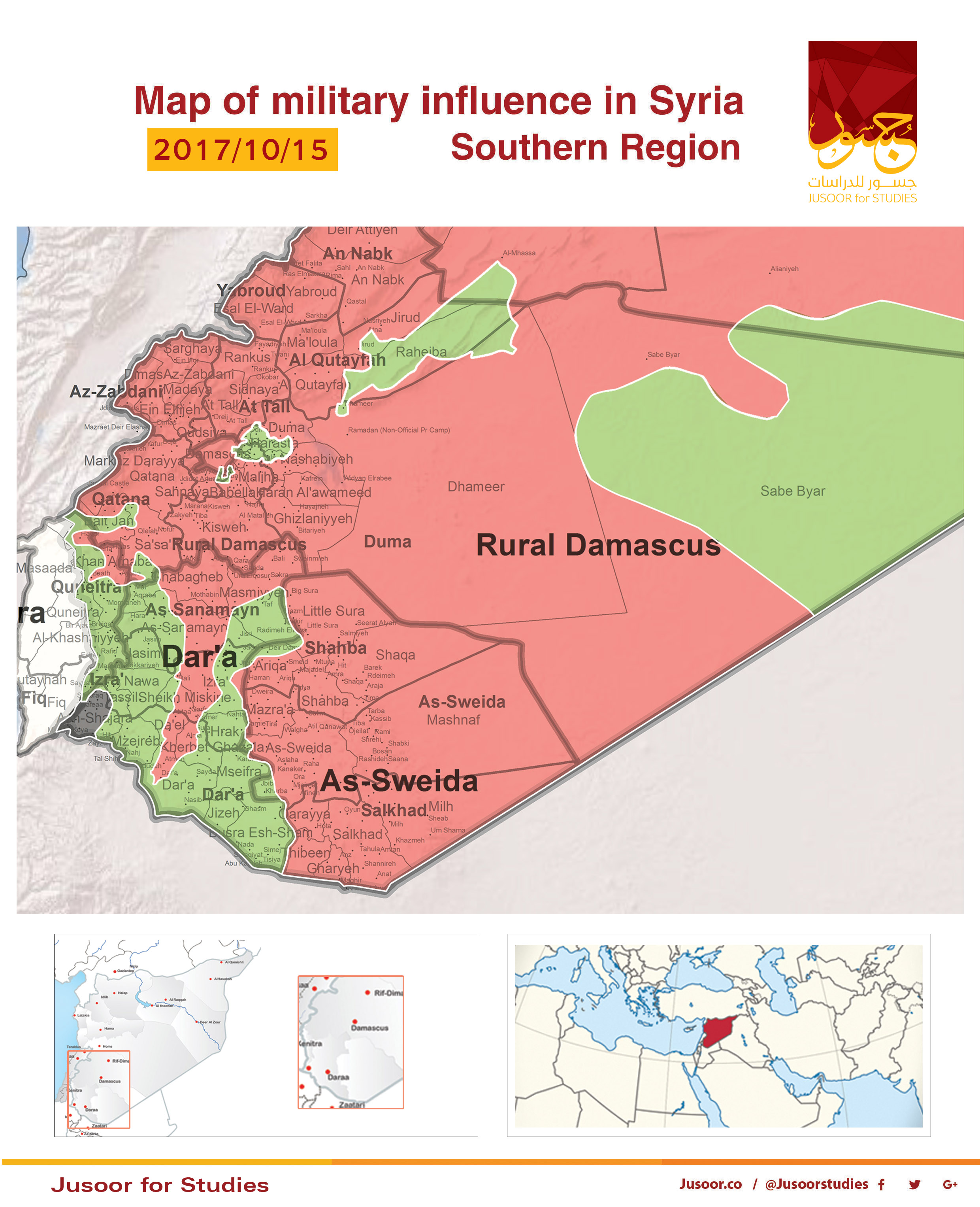
The Southern Region
The map shows substantial changes of the influence by different sides in the Southern Region between October 1, 2017, and October 15, 2017.
Assad forces have controlled about 5000 KM2 of Al Badia between As-Suwayda and Damascus Countryside on the account of FSA, as the last party has retreated to Tanf area. It is possible that an agreement took place between International Coalition and Jordan from one side and Russia on the other side with regards to the current realities in Al Badia consequently, FSA military influence has shrunk considerably during October.
As for Eastern Al Ghouta, there are constant violations between Assad forces and FSA, while the first party expanded its military operations to include Hosh al-Dawahra, Ein Tarma, and Jobar without making any progress. On the other hand, the Syrian regime sends military build-up towards Western Al Ghouta in order to control more areas on the account of FSA. However, Assad forces have failed to make any progress in that areas.