Control over Road Network 15 June 2016
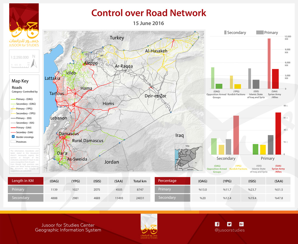
JUSOOR for STUDIES center has released a map that shows the influence of different forces in SYRIA over the roadway network, specially the main roadway and the first class sub-roadway.
By main roadway in this map we mean all international roadways and autobahns that link the centers of Provinces with each other, while we mean by the sub-roadway all roadway that link Communities and Vital facilities (Border crossings, industrial cities …) outside the former communities.
According to the study of JUSOOR for studies center, the length of the roadway network is about 33000 km, 8500 km of each are main and international and 24000 are sub-roadway.
This study shows that the Syrian armed forces controls long parts of the main axis of the roadway network including Damascus-Aleppo autobahn, considering that his control over the majority of the densely populated areas has given him the opportunity to have the biggest ratio (nearly 50%) of control over the roadway network with both main roads and sub-roads.
Even though the Opposition Armed Groups doesn't control but 13% of the main roadway and 20% of sub-roadway, these ratios are still in proportion with the influence area of these groups, which indicates clearly the effectiveness of the geographic influence compared to the effective influence over the vital facilities, this index appears clearly when we analyze the influence ratios of ISIS, although it controls a vast area of SYRIAN territories but this control appears weak when speaking about roadway network, because the majority of the territories controlled by ISIS are not densely populated areas, and located in the SYRIAN desert nearly depopulated (see Map of Military Influence May 2016).
This map is part of a Program run by JUSOOR for STUDIES center to study the military influence periodically, the center release monthly maps of military influence over geographic areas, in addition to reports and studies to analyze the political and military progress in SYRIA.


