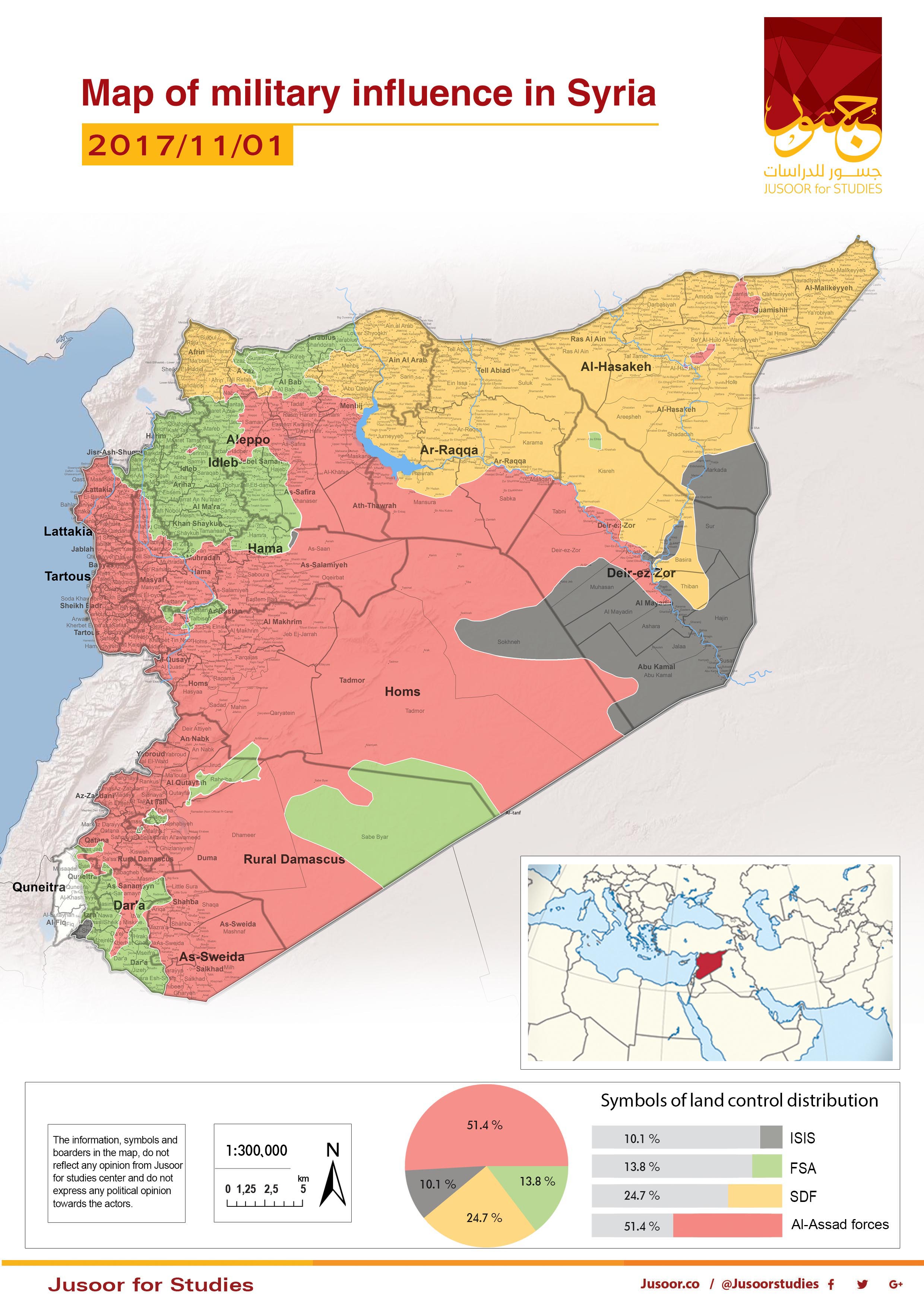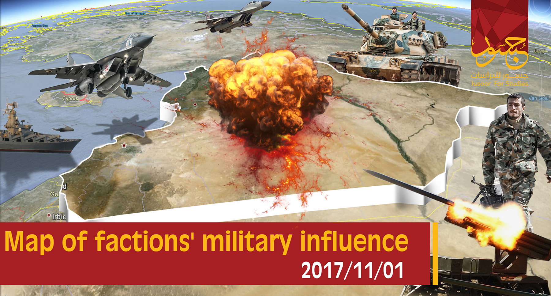
Map of military influence in Syria 01-11-2017
Font Size
Jusoor for Studies Center issued the map of military influence in Syria for the second half of October 2017, as it shows a constant change in the total military influence percentage between the different forces. There is a notable increase in the total influence of Assad forces and Syria Democratic Forces (SDF) on the account of ISIS and the Free Syrian Army (FSA) and the new percentages are as follows:
• A decrease in ISIS-controlled areas on the account of Assad’s forces and SDF, while ISIS controls 10.1% of areas which means 1.9% decrease since mid of October 2017.
• Assad’s forces controls 51.4 % which means 0.8% increase since mid of October 2017.
• SDF controls 24.7% of areas which mean 1.1 % increase especially, after seizing Raqqa city on October 20, 2017.
• FSA kept the same percentage since mid of October 2017, which is 13.8%.
The last fifteen days have witnessed a constant violation of the de-escalation agreement in Eastern Ghouta fronts and no progress was made by any side, while Assad’s forces were able to make progress on the account of HTS Hama eastern countryside.
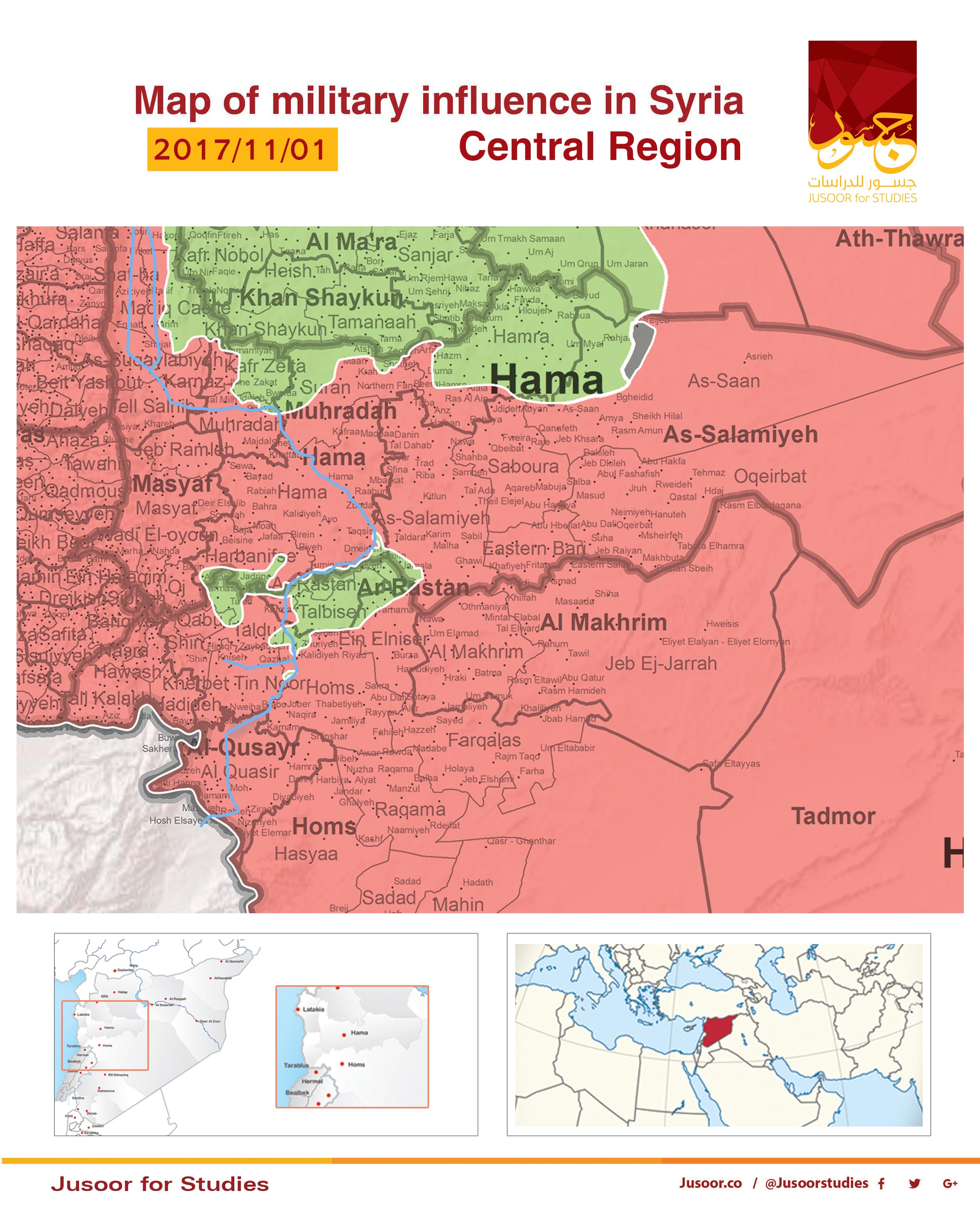
The Central Region:
The map shows a slight change of the controlled areas in the Central Region by different military sides.
Many violations of the de-escalation agreement have taken place in Hama eastern countryside, whereby HTS started the violation by attacking and controlling Abu Dali village on September 19, 2017. Conversely, Assad’s forces controlled Jib Abyad village in Hama northern countryside. Assad’s forces continued their advancement through area recaptured from ISIS and reached Abu Salf village but HTS recaptured the village. On the other hand, areas under ISIS control became very few in Hama eastern countryside, as it controls some villages northwest of Jrouh village.
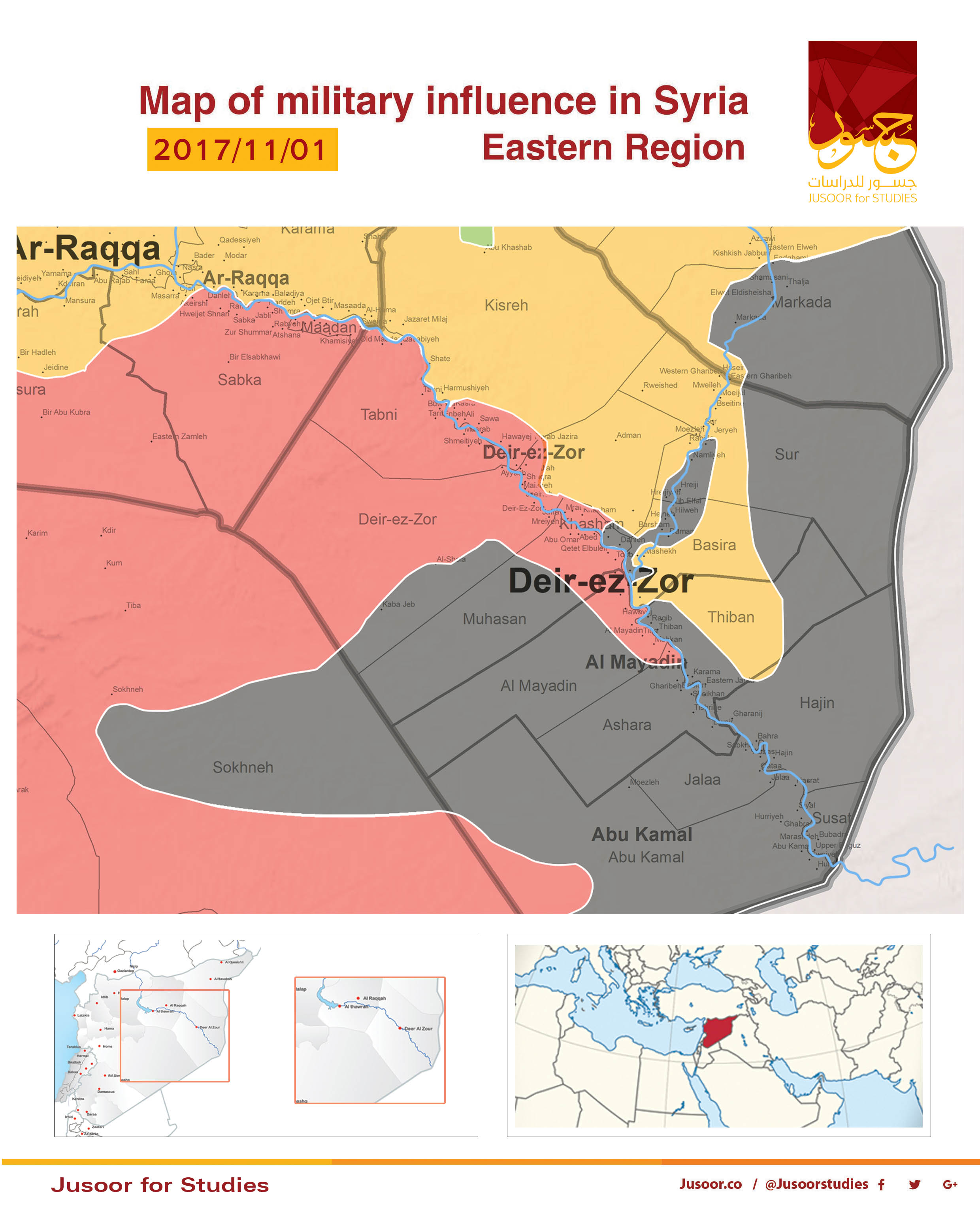
The Eastern Region:
The map shows different percentages of influence by different sides in the Eastern Region.
ISIS continues its control on the road between Al Sukhna city and Deir ez-Zor (ISIS cut off the road on 28/9/2017), while Assad’s forces were able to control Al Mayadin city in Deir ez-Zor eastern countryside on October 14, 2017, and continued their advance south of Euphrates River and controlled Al Quriyah town. Moreover, Assad’s forces made a progress in Deir ez-Zor city and increased the siege on ISIS combatants in addition to controlling Hweijat Saker, Khasham, and Tabiyah towns north of Euphrates River.
SDF continued its progress towards Deir ez-Zor eastern countryside, controlling Al Omar strategic oil field on the 23/10/2017 and headed towards Al Sh-heil town and controlled it later which caused a siege on ISIS combatants is many towns and villages.
Assad’s forces made a notable progress in Al Badia fronts near the Syrian-Iraqi borders. While T2 Pumping Station was controlled by pro-government forces in addition to controlling Al Hmeimieh town.
The Southern Region:
The map shows no changes of the influence by different sides in the Southern Region.
As in the first half of October 2017, Assad forces controlled about 5000 KM2 of Al Badia between As-Suwayda and Damascus Countryside on the account of FSA, as the last party has retreated to Tanf area, while in the second half of October 2017 no progress has taken place.
As for Eastern Al Ghouta, there are constant violations between Assad forces and FSA, while the first party tries to seize Ein Tarma, and Jobar without making any progress. On the other hand, the Syrian regime has failed to make progress in Western Al Ghouta especially, in Beit Jin and Beit Sater fronts which are controlled by FSA.
Many violations of the de-escalation agreement have taken place in Hama eastern countryside, whereby HTS started the violation by attacking and controlling Abu Dali village on September 19, 2017. Conversely, Assad’s forces controlled Jib Abyad village in Hama northern countryside. Assad’s forces continued their advancement through area recaptured from ISIS and reached Abu Salf village but HTS recaptured the village. On the other hand, areas under ISIS control became very few in Hama eastern countryside, as it controls some villages northwest of Jrouh village.
The Eastern Region:
The map shows different percentages of influence by different sides in the Eastern Region.
ISIS continues its control on the road between Al Sukhna city and Deir ez-Zor (ISIS cut off the road on 28/9/2017), while Assad’s forces were able to control Al Mayadin city in Deir ez-Zor eastern countryside on October 14, 2017, and continued their advance south of Euphrates River and controlled Al Quriyah town. Moreover, Assad’s forces made a progress in Deir ez-Zor city and increased the siege on ISIS combatants in addition to controlling Hweijat Saker, Khasham, and Tabiyah towns north of Euphrates River.
SDF continued its progress towards Deir ez-Zor eastern countryside, controlling Al Omar strategic oil field on the 23/10/2017 and headed towards Al Sh-heil town and controlled it later which caused a siege on ISIS combatants is many towns and villages.
Assad’s forces made a notable progress in Al Badia fronts near the Syrian-Iraqi borders. While T2 Pumping Station was controlled by pro-government forces in addition to controlling Al Hmeimieh town.
The Southern Region:
The map shows no changes of the influence by different sides in the Southern Region.
As in the first half of October 2017, Assad forces controlled about 5000 KM2 of Al Badia between As-Suwayda and Damascus Countryside on the account of FSA, as the last party has retreated to Tanf area, while in the second half of October 2017 no progress has taken place.
As for Eastern Al Ghouta, there are constant violations between Assad forces and FSA, while the first party tries to seize Ein Tarma, and Jobar without making any progress. On the other hand, the Syrian regime has failed to make progress in Western Al Ghouta especially, in Beit Jin and Beit Sater fronts which are controlled by FSA.